Table of contents
- Table of contents
- Introduction
- Reference
- Executable form
- Type
- Diagram of 2D SLAM
- Accumulated error problem
- Data association
- Loop closure
- Batch processing
- Sequential processing
Introduction
I studied SLAM refer to the following book. I'm introducing my studying log in dividing into multiple articles. In this article, I wrote some fundamental knowledge of SLAM as memo.
Reference

- 作者: 友納正裕
- 出版社/メーカー: オーム社
- 発売日: 2018/03/03
- メディア: 単行本(ソフトカバー)
- この商品を含むブログ (2件) を見る
Executable form
First problem of executing SLAM is how a trajectory for getting sensor data should be decided. There are 2 kinds of way to decide the trajectory.
- A robot is given the trajectory by human
- The robot decide the trajectory automatically
Type
| SLAM type | Dimension of robot pos | Dimension of map | Sensor type |
|---|---|---|---|
| 2D/2D type | 2D | 2D | 2D LiDAR, Odometry, Gyro |
| 2D/3D type | 2D | 3D | 2D/3D LiDAR, Camera, Odometry, Gyro |
| 3D/3D type | 3D | 3D | 3D LiDAR, Camera, IMU |
Diagram of 2D SLAM
The following diagram is an example of 2D/2D SLAM.
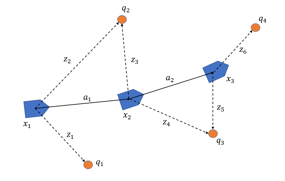
State of Robot

Measurement data

Landmark

Amount of movement by Odometry

Rotation matrix

Translation vector

Calculating landmark position depend on robot position

Predicting robot position by odometry
The amount of movement by odometry is minute and the robot can be assumed that it is moving straight. At the same time, an component y can be assumed as 0.

This calculation can be expressed like the following formula.

Accumulated error problem
To resolve this problem, the robot need to measure same landmark multiple times. And then, the robot position can be modified by calculating backward with measured landmark position. In the above diagram, the following simultaneous equations. x1 is an initial position and can not be decided. This is defined as an appropriate constant valuables(usually, the origin of map coordinate system).
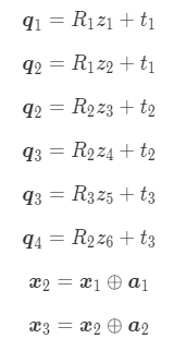
Typically, this simultaneous equations can be solved by least squares method.
Data association
Typically, association with only position constraint is not efficient. If there were two landmarks at almost same position, it would be difficult to decide which landmarks should be associated. Firstly, association candidates are reduced with an feature value. After that, position constraint will be used for the association.
Loop closure
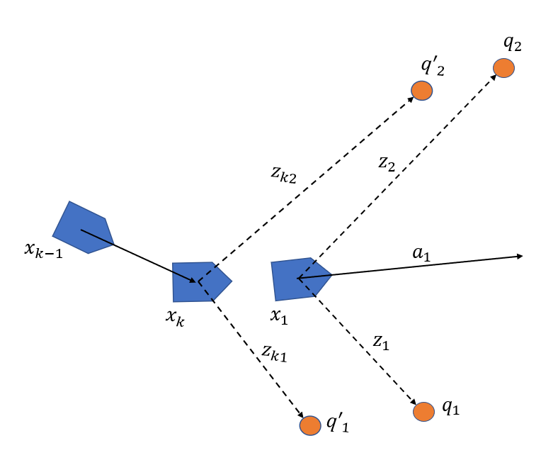
Loop closure is executed by the following sequence.
Loop detection
Detecting what the robot returned same position. The following diagram is before loop detection. Land markand
,
and
are same landmarks each other. At that time, the robot position
will be modified as a position where
and
,
and
become same.
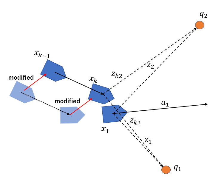
Modifying robot trajectory and map
The original robot positionwill be modified as follow. And then,
need to be modified too because the difference of those positions.
Batch processing
- Robot needs sufficient many sensor data to execute SLAM. This processing is not suitable for real time processing.
- It takes long time to process but an accuracy of map is good.
Sequential processing
- Map is being constructing in real time sequentially. This is effective to work in a unknown or dynamic environment.
- Only part of all sensor data is used. The processing time is short but an accuracy of map is not good.